Glimpse Into the Future: Esri’s Living Atlas Develops 2050 Map
Climate change has resulted in growing concern about how our planet would look like in 2050. By understanding the change over a period, it is possible to make foundational predictions and create estimated growth patterns for the future. Esri has developed a map of the earth for the year 2050, which gives a gloomy glimpse into the future amid climate change.
By observing the changes in the past and recorded historic global land cover data, Clark labs at Clark University and Esri aim to predict the change in land cover by 2050. New series of maps have been developed based on decades of satellite observation data gathered from the European Space Agency (ESA) – Climate Change Initiative (CII).
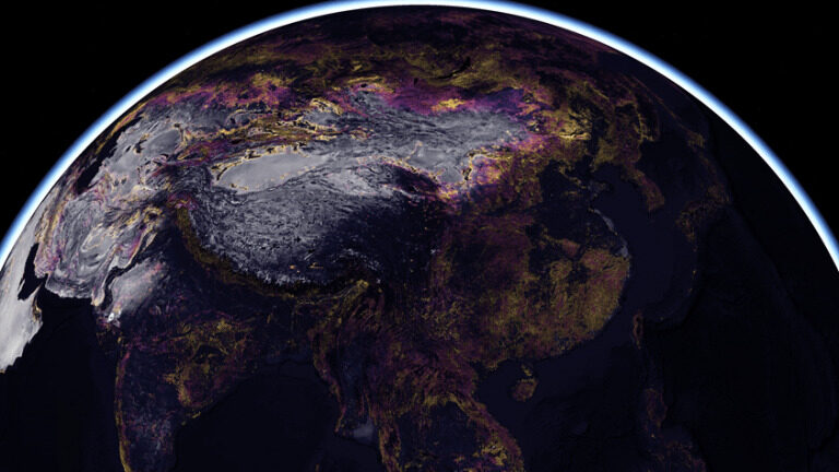
Esri gives a glimpse of how the land cover would be in 2050 | Image: ESRI
This interactive map highlights the impact of industrial development and climate change on earth. The new 2050 global land cover map gives a glimpse into the next three decades and an insight into the vulnerability of the earth in 2050.
To identify the areas with the most vulnerable changes, every country’s land cover was analyzed to create a vulnerability model which reflects how development can transform natural vegetation into urban lands by 2050. The land cover vulnerability model is based on an algorithm of several quantitative and qualitative variables that shows land development, geophysical, and bioclimate data.

Image: NASA
Coastal areas are most likely to observe urban development and artificial spaces, which can be harmful considering the recently published by NASA on coastal flooding. The report found that due to sea-level rise from climate change and ‘wobbly’ lunar orbit, flooding would be common on coasts by 2030.
To improve understanding of a sustainable future, Esri will provide the 2050 Land Cover map series as a freely accessible resource. These maps are a part of the growing map layers collection in Esri’s ArcGIS Living Atlas of the World, which will be assessed under Creative Commons license (CC-BY-4.0).
With the recent additions in the Living Altas, authoritative sources will have access to trend data, emphasizing study towards climate change and global warming.
Via: Slash Gear